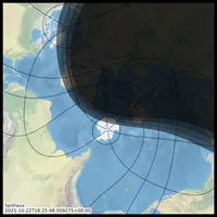
i can't afford a what?
what am i going to do about it?
get a high paying job[2]make one myself[3]get a raspberry pi & a small screen and make a little digital version[4]- write some wobbly code to change my desktop background every 5 minutes[5]
what i did about it
skip to the output. No offense taken.
Firstly, work out how to plot the terminator. A bit of time searching for libraries that can do it out of the box, then some translating, followed by working out what exactly their code was doing. Secondly, realise that cartopy has a nice implementation: Nightshade, and that I just wasted an hour or so.
Next, establish that the terminator cartopy generates plays nicely with cartopy's projection capabilities, naturally. Great. Then it's just a case of wasting another hour or so trying to add the bands for civil, nautical and astronomical twilight [6], before realising that the refraction parameter of Nightshade can be used as an
adjustment in degrees due to refraction, thickness of the solar disc, elevation[7] etc...
Bingo. Just run Nightshade a few times with different refraction and alpha values.
Nightshade(date, alpha=0.5)
Nightshade(date, alpha=0.4, refraction=-18.0)
Nightshade(date, alpha=0.3, refraction=-12.0)
Nightshade(date, alpha=0.2, refraction=-6.0)
Slap the timestamp in the corner[8]. And job done.
Wrong.
add a bit of complexity that definitely doesn't speed it up
Pick a random projection each time, customising the projection such that the central_longitude and central_latitude (if applicable) parameters are set to the lat, lon of the where the sun is directly over head. Oh, and whilst we're playing with those lat lon values, might as well plot them as a little yellow * on the map.
also add:
- gridlines: equator, tropics and the ant/arctic circles, along with every 60 degrees of longitude
- the name of the projection
- the projection parameters
Right. How do I change the desktop background? And can I remember how to use cron, or is it crontab? Who knows.
gsettings set org.gnome.desktop.background picture-uri file:///path/to/file/now.png&
@reboot /usr/bin/env bash /path/to/script/changeDesktop.sh
*/5 * * * * /usr/bin/env bash /path/to/script/changeDesktop.sh
apparently
That didn't do it. Wait. Yes it did. The probelm was the not activating my conda environment in that script. Fixed. Done.

hopefully
having a steady stream of different projections put in front of me, means I might inadvertantly learn their names. Maybe even learn to distinguish EckertI from EckertII.
upgrades
a nicer base map. at some point. or maybe even some live[9] images of a EUMETSAT or somewhere.