# tlohde

Access to the Railways
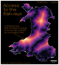
Map of Wales. Titled: 'Access to the Railways' The map is a proximity surface, with bright colors representing large distances from a railway station, and darker colors closer to train stations. Additionally the proximity surface is shown with illuminated contours giving the a 3d-ish feel, with the railways running along ridges, and places far from the network appearing to be at the bottom of a hill. The middle of snowdonia and a portion of the west coast are shown as being the furthest from the network. An annotation reads: 'Llangrannog the furthest village from a train station (in a straight line)'. At the top right some text reads: 'Platform Wales'. the credits read: 'by tlohde / OpenStreetMap Contributors'
Access to the Railways: Proximity* to a train station. *as the crow flies. Made for day 7 of the 2025 #30DayMapChallenge: Accessibility. I feel like the colourmap & font colour don't quite work together.

tools Python: matplotlib for plotting; geopandas for wrangling; scipy for constructing the KDTree
data OpenStreetMap contributors
font Metro Time Sign