# tlohde

Depth of Superficial Deposits
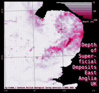
A map of East Anglia, UK. No features have been drawn on the map, however the land is coloured from white to pink to dark pink depending on the depth of superficial deposits. The majority of the region is white, however there are some bands of pink and a few patches of dark pink, neart the Suffolk/Norfolk border. In the top right is a histogram showing the distribution of depths. The frequency is shown on a log-scale, indicating most areas have no deposits, but some have up to 100 m. The title runs downt the right side of the plot and reads: 'Depth of Superficial Deposits East Anglia UK' and is written in white with a large drop shadow in dark pink. The north sea / background is black, which makes the whole image quite high contrast. Credits along the bottom read: 'by:tlohde / ‘Contains British Geological Survey materials © UKRI 2025'
Depth of Superficial Deposits: Distribution of superficial deposits courtesy of previous glaciations. Made for day 5 of the 2025 #30DayMapChallenge: Earth. Note the log-x axis.

tools python: geopandas, cartopy and matplotlib
data Contains British Geological Survey Materials © UKRI 2025
font Deja Vu Sans Mono