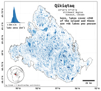
| projection |
UTM Zone 14N
|
| tools |
Python libraries: osmnx (for getting data); geopandas for wrangling; matplotlib for plotting.
|
| data |
OpenStreetMap contributors
|
| font |
Recursive Sans & Mono, by Stephen Nixon, with Lisa Huang, Katja Schimmel. Rafał Buchner & Ben Kiel
|
| comments |
Log-scale histograms aren't the most intuitive of things to interpret. And for that I'm sorry. Not colouring in the sea was a mistake; ditto shunning a graticule, as that would certainly help break up the whiteness. I feel the whole scene is missing some sort of texture.
|
| date |
03/11/2025
|
