# tlohde

The Volcanic Isles

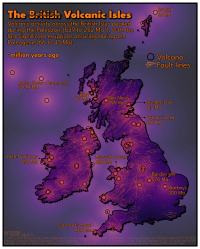
Map of the British Isles showing the location of extinct volcanoes (unfilled black circle markers). and bedrock fault lines (orange lines). The coastline is shown in thick black, with a slight dropshadow. The map is coloured in such that the volcanoes are a bright orange/yellow, and the colour moves to a darker purple with distance from a volcano. The same colourscheme is applied at sea, however with reduced opacity. The title text reads: 'The ~~British~~ Volcanic Isles' with subheading: 'Volcanic activity across the British Isles peaked during the Paleozoic (539 to 252 Ma*), with the last significant eruptions occuring during the Paleogene (66 to 43 Ma).  *million years ago'. A few key volcanoes are highlighted: Anton Dohrn Seamount (70-41 Ma); Erlend (58 Ma); Rum (60 Ma); Ben Nevis (299 Ma); Dundee Law (415 Ma); Arthur's Seat (299 Ma); Loch Na Fooey (490 Ma); Mynydd y Dref (450 Ma); Bardon Hill (570 Ma); Warboys (300 Ma); Gurnard's Head (400 Ma)
The Volcanic Isles: A brief history of volcanism across the British Isles. Fault lines and extinct volcanoes (/centres of volcanism / remnants of volcanoes). The south east seemed to dodge the worst of it. This was made for day 15 of the 2025 #30DayMapChallenge: Fire. A proximity surface was generated to show distance to the nearest volcano, and this was plotted twice: once for on land, and again with reduced opacity at sea. Whilst inspecting the underlying data I spotted, and corrected, the location of Langdale Caldera in the Lake District, whoose longitude was down as East, when it should have been West.

tools Python: matplotlib for plotting; geopandas and pandas for wrangling; scipy for constructing the KDTree used to generate the proximity surface. This was exported and labelling was done, manually, in Inkscape
data Locations of volcanoes and their approximate ages / date of last eruption came from the List of volcanoes in the United Kingdom, and List of volcanoes in the Republic of Ireland. Fault lines are from the British Geological Survey's 625k bedrock dataset for UK and Northern Ireland, and from the IE GSI Bedrock Geology Datasets 500k Ireland (ROI/NI) for the Republic of Ireland. The coastline is from Natural Earth
font League Spartan by The League of Moveable Type