# tlohde

Topography and Toponymy

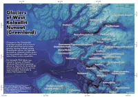
A map showing the bathymetry and sub-glacial topography across West Greenland. The topography is on a black to dark blue to light blue color ramp. Contours are drawn and 250 m intervals. There are many fjords and islands. Several fjords have regions where the depth is 1000+ m. There is a subtle hill-shade layer on top of the terrain. There are ~30 glaciers marked as small orange crosses,  with their names written along side. The names are in Greenlandic, for example: Nunaarsussuup Oqquatungaani Sermikassak, Tassartooq, Sermikassak, Umiammakku Sermiat, Nakkala, and Kangilleq. The map is titled: 'Glaciers of West Kalaallit Nunaat (Greenland)' with the following text below: 'Changes to the Greenlandic language coupled with a history of exploration has led to many glaciers having multiple names. Greenlandic names are typically descriptive, whereas names given during expeditions are often say more about those on the expedition. For example, Rink Isbræ was named in honour of Hinrich Johannes Rink (Isbræ meaning glacier in Danish). Its Greenlandic name: Kangilliup Sermia, can be approximately translated to mean: The Eastern Ice.' In the bottom left the data sources are credited: 'Greenlandic Glacier Names by Bjørk, Anders; Kruse, Lisathe; Michaelsen, Peter (2015). https://doi.org/10.6084/m9.figshare.1449148.v2 & BedMachine Greenland by Morlighem, M. et al. (2022). https://doi.org/10.5067/GMEVBWFLWA7X. Date Accessed 24-11-2025.' & in the bottom right it reads : 'by:tlohde'
Topography and Toponymy: The bathymetry and sub-glacial topography of west Greenland, along with the Greenlandic names for the Greenlandic glaciers. Made for day 24 of the 2025 #30DayMapChallenge: places and their names

tools All QGIS
data Glacier Names from Bjørk, Anders; Kruse, Lisathe; Michaelsen, Peter (2015). linky and subglacial topography & bathymetry from BedMachine v5 by Morlighem, M et al. (2022)
font League Spartan by The League of Moveable Type