# tlohde

Visibility in the Cairngorms
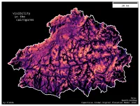
A map of the Cairngorms national park. Black background with white national park border. Within the national park the terrain is represented by colors ranging from black through dark purples to bright orange. Brighter colours represent regions that are 'more visible' than darker regions, as these areas can be seen from more summits. The resulting sum of viewsheds bears strong resemblance to the underlying topography.
Visibility in the Cairngorms: This was Day 20 of the 2023 #30DayMapChallenge (theme: outdoors). I've long been fascinated by viewsheds, and what can be seen. Viewsheds for every peak in the Cairngorms were computed, and the resulting binary masks (visible/not = 1/0) summed. Brighter areas can be seen from more summits. Cac Càrn Beag (1156 m) in the South East of the park wins the prize for most visible, as it can be seen from 289 other summits.

tools python: geopandas, matplotlib, osmnx, cartopy, rioxarray, gdal, rasterio.
data OpenStreetMap contributors, Copernicus Global DEM (ESA)
font Deja Vu Sans Mono